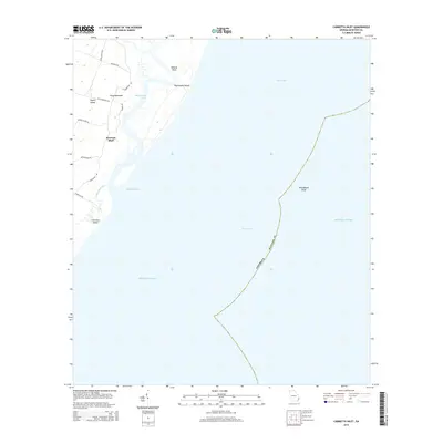
2014 Map of Cabretta Inlet
USGS Topo · Published 2014About this map
Sapelo Island and Blackbeard Island dominate this coastal survey of McIntosh County, separated by the winding course of Blackbeard Creek. The settlement of Raccoon Bluff sits along the western shoreline of the barrier islands, connected by a network of local roads including Miller Pump Rd and Church Rd. The geography is defined by the transition from tidal marshes to the open waters of the Atlantic Ocean, with Cabretta Inlet providing passage between the southern tip of Blackbeard Island and Cabretta Island. To the east, the submerged hazards of Blackbeard Shoal extend into the sea, while Nelsons Bluff marks a distinct elevation point on the marshy interior. The infrastructure shown here, such as King Savannah Rd and Tanners Trl, illustrates the localized access within these protected island environments.
Find a feature on this map
22 named features on this map. Tap any name to fly to it.
Don’t see what you’re looking for? This feature index may not catch every label — zoom into the map to look around manually.
Map Details
Editions of this 2014 Cabretta Inlet Map
This is the sole edition of this map. No revisions or reprints were ever made.
Other maps of this area

1920 · Sapelo River
USGS Topo · 1:62,500

1920 · Cabretta Island
USGS Topo · 1:62,500

1921 · Darien
USGS Topo · 1:62,500

1928 · St Catherines Island
USGS Topo · 1:62,500

1943 · St Catherines Island
USGS Topo · 1:62,500

1943 · Sapelo River
USGS Topo · 1:62,500

1944 · Cabretta Island
USGS Topo · 1:62,500

1945 · St. Catherine's Island
USGS Topo · 1:62,500

1945 · Sapelo River
USGS Topo · 1:62,500

1946 · Brunswick
USGS Topo · 1:250,000