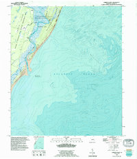
1993 Map of Cabretta Inlet
USGS Topo · Published 1995About this map
Blackbeard Island and Sapelo Island dominate this coastal survey, where the intricate tidal systems of the Georgia coast meet the Atlantic Ocean. The landscape is defined by its conservation status, split between the Blackbeard Island National Wildlife Refuge and the Richard J. Reynolds State Wildlife Management Area. Cultural history is noted through several ruins and a lone grave near the western marsh edge, suggesting earlier human activity within these now protected habitats. The eastern shoreline is characterized by significant sand dunes and the shifting shoals of Cabretta Inlet, an area noted as being subject to frequent change. Inland, named clearings like Bourbon Field and King Savannah punctuate the dense maritime environment, while high ground is marked by Raccoon Bluff and Nelsons Bluff overlooking Blackbeard Creek.
Find a feature on this map
20 named features on this map. Tap any name to fly to it.
Don’t see what you’re looking for? This feature index may not catch every label — zoom into the map to look around manually.
Map Details
Editions of this 1993 Cabretta Inlet Map
This is the sole edition of this map. No revisions or reprints were ever made.
Other maps of this area

1920 · Sapelo River
USGS Topo · 1:62,500

1920 · Cabretta Island
USGS Topo · 1:62,500

1921 · Darien
USGS Topo · 1:62,500

1928 · St Catherines Island
USGS Topo · 1:62,500

1943 · St Catherines Island
USGS Topo · 1:62,500

1943 · Sapelo River
USGS Topo · 1:62,500

1944 · Cabretta Island
USGS Topo · 1:62,500

1945 · St. Catherine's Island
USGS Topo · 1:62,500

1945 · Sapelo River
USGS Topo · 1:62,500

1946 · Brunswick
USGS Topo · 1:250,000