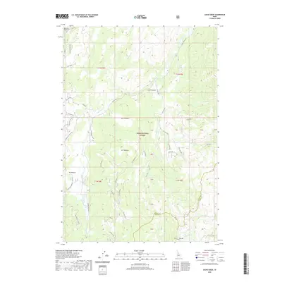
2020 Map of Cache Creek
USGS Topo · Published 2020About this map
Boise National Forest encompasses this high-altitude landscape where Bear Valley Creek and its many tributaries, such as Sack Creek and Mace Creek, carve through the terrain. The map reveals a complex network of high-elevation meadows, including Mace Meadows, Cache Meadows, and Lost Meadows, which define the drainage basins between prominent rises. The southwestern corner is anchored by the Whitehawk Lookout, providing a strategic vantage over the drainage of Cosner Creek.
Find a feature on this map
52 named features on this map. Tap any name to fly to it.
Don’t see what you’re looking for? This feature index may not catch every label — zoom into the map to look around manually.
Map Details
Editions of this 2020 Cache Creek Map
This is the sole edition of this map. No revisions or reprints were ever made.
Other maps of this area

1891 · Bear Valley
USGS Topo · 1:125,000

1893 · Bear Valley
USGS Topo · 1:125,000

1909 · Garden Valley
USGS Topo · 1:125,000

1953 · Deadwood Reservoir
USGS Topo · 1:62,500

1957 · Challis
USGS Topo · 1:250,000

1960 · Challis
USGS Topo · 1:250,000

1963 · Challis
USGS Topo · 1:250,000

1972 · Bull Trout Point
USGS Topo · 1:24,000

1972 · Cache Creek
USGS Topo · 1:24,000
1972 · Miller Mtn East
USGS Topo · 1:24,000