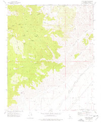
1973 Map of Cache Peak
USGS Topo · Published 1977About this map
Petroglyphs near Jawbone Canyon signal the deep historical roots of this high-desert landscape during the early 1970s. The map illustrates a terrain defined by water scarcity and resource extraction, where vital water sources like Golden Oaks Spring, Champagne Spring, and Megs Mud Spring are named alongside multiple Prospects and the Skyline Mine. The massive engineering of the Second Los Angeles Aqueduct cuts across the southeastern corner, illustrating the twentieth-century effort to move water from the eastern Sierra Nevada toward the coast. This industrial infrastructure contrasts with the numerous primitive routes and trails, such as the Randsburg Cutoff, that navigate the elevations of Cache Peak and Middle Knob. The presence of Airplane Flat and Weldon Pond amidst the ridges provides a look at the varied topography of the North Fork and Pine Tree Canyon drainage systems.
Find a feature on this map
30 named features on this map. Tap any name to fly to it.
Don’t see what you’re looking for? This feature index may not catch every label — zoom into the map to look around manually.
Map Details
Editions of this 1973 Cache Peak Map
4 editions found
Other maps of this area

1915 · Mojave
USGS Topo · 1:125,000

1943 · Tehachapi
USGS Topo · 1:62,500

1943 · Cross Mountain
USGS Topo · 1:62,500

1943 · Emerald Mtn
USGS Topo · 1:62,500

1943 · Mojave
USGS Topo · 1:62,500

1947 · Plano
USGS Topo · 1:24,000

1947 · Mojave
USGS Topo · 1:24,000

1948 · Bakersfield
USGS Topo · 1:250,000

1955 · Bakersfield
USGS Topo · 1:250,000

1956 · Bakersfield
USGS Topo · 1:250,000