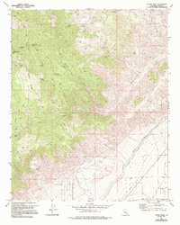
1973 Map of Cache Peak
USGS Topo · Published 1994About this map
Cache Peak dominates this high-desert landscape in Kern County, where the infrastructure of water transport meets the ancient traces of the land. The presence of Petroglyphs near Jawbone Canyon indicates a deep human history long before the construction of the Los Angeles Aqueduct and Second Los Angeles Aqueduct, which cut through the southeastern portion of the map. The terrain is marked by numerous water sources critical to travel and survival, including Champagne Spring, Quail Spring, and Eagle Spring.
Find a feature on this map
33 named features on this map. Tap any name to fly to it.
Don’t see what you’re looking for? This feature index may not catch every label — zoom into the map to look around manually.
Map Details
Editions of this 1973 Cache Peak Map
4 editions found
Other maps of this area

1915 · Mojave
USGS Topo · 1:125,000

1943 · Tehachapi
USGS Topo · 1:62,500

1943 · Cross Mountain
USGS Topo · 1:62,500

1943 · Emerald Mtn
USGS Topo · 1:62,500

1943 · Mojave
USGS Topo · 1:62,500

1947 · Plano
USGS Topo · 1:24,000

1947 · Mojave
USGS Topo · 1:24,000

1948 · Bakersfield
USGS Topo · 1:250,000

1955 · Bakersfield
USGS Topo · 1:250,000

1956 · Bakersfield
USGS Topo · 1:250,000