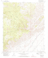
1973 Map of Cache Peak
USGS Topo · Published 1983About this map
Cache Peak dominates this high-altitude landscape of eastern Kern County, where the southern Sierra Nevada transitions toward the desert. The terrain is marked by a complex network of springs, including Peeping Tom Spring, Champagne Spring, and Golden Oaks Spring, which historically supported movement through this arid environment. Indigenous presence is anchored on the map by Petroglyphs located north of Jawbone Canyon, while later industrial efforts are evidenced by the Skyline Mine and various Prospects scattered across the eastern ridges. A significant feat of engineering, the Los Angeles Aqueduct and the Second Los Angeles Aqueduct cut through the southeastern corner of the quadrangle. These water systems, running parallel to the Randsburg Cutoff, illustrate the critical infrastructure required to transport resources across the Barren Ridge to the growing metropolitan centers to the south.
Find a feature on this map
30 named features on this map. Tap any name to fly to it.
Don’t see what you’re looking for? This feature index may not catch every label — zoom into the map to look around manually.
Map Details
Editions of this 1973 Cache Peak Map
4 editions found
Other maps of this area

1915 · Mojave
USGS Topo · 1:125,000

1943 · Tehachapi
USGS Topo · 1:62,500

1943 · Cross Mountain
USGS Topo · 1:62,500

1943 · Emerald Mtn
USGS Topo · 1:62,500

1943 · Mojave
USGS Topo · 1:62,500

1947 · Plano
USGS Topo · 1:24,000

1947 · Mojave
USGS Topo · 1:24,000

1948 · Bakersfield
USGS Topo · 1:250,000

1955 · Bakersfield
USGS Topo · 1:250,000

1956 · Bakersfield
USGS Topo · 1:250,000