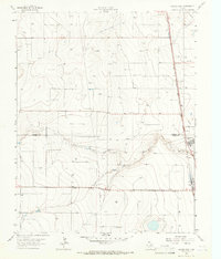
1965 Map of Cactus West
USGS Topo · Published 1966About this map
North Palo Duro Creek carves a distinct path through the High Plains landscape of the Texas Panhandle, crossing the boundary between Sherman Co and Moore Co. In the mid-1960s, this area reflects a specialized industrial and agricultural character, dominated by energy extraction and rail logistics. Numerous Gas Wells and Wells dot the terrain, connected by a network of pipelines that traverse the plains. The concentrated settlements of Cactus and Etter serve as focal points for the region's industry, supported by a dual-rail network. The Atchison Topeka and Santa Fe and Chicago Rock Island and Pacific railroads meet here, facilitating the movement of resources. Local infrastructure like a Pumping Sta, Water Tank, and various Gravel Pits highlight the active maintenance and industrial utility of the Panhandle during this era.
Find a feature on this map
15 named features on this map. Tap any name to fly to it.
Don’t see what you’re looking for? This feature index may not catch every label — zoom into the map to look around manually.
Map Details
Editions of this 1965 Cactus West Map
This is the sole edition of this map. No revisions or reprints were ever made.
Other maps of this area

1954 · Tucumcari
USGS Topo · 1:250,000

1954 · Perryton
USGS Topo · 1:250,000

1954 · Amarillo
USGS Topo · 1:250,000

1954 · Dalhart
USGS Topo · 1:250,000

1958 · Perryton
USGS Topo · 1:250,000

1958 · Amarillo
USGS Topo · 1:250,000

1958 · Tucumcari
USGS Topo · 1:250,000

1958 · Dalhart
USGS Topo · 1:250,000

1962 · Dalhart
USGS Topo · 1:250,000

1963 · Cactus East
USGS Topo · 1:24,000