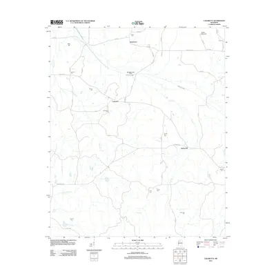
2012 Map of Cadaretta
USGS Topo · Published 2012About this map
Cadaretta and the surrounding rural landscapes of Webster County are defined by a dense network of family and community burial grounds, illustrating a deeply rooted settlement pattern. The area is intersected by the winding course of Sabougla Creek and the engineered Sabougla Creek Canal, which manage the drainage of this hilly region. High points like Bald Hill and Sandy Mountain overlook a terrain carved by numerous tributaries including Horse Pen Creek, Lindsay Creek, and Little Bogue. The map reveals the persistence of small rural hubs such as Dentontown and Spring Hill, where Spring Hill Cemetery and Bethel Cemetery serve as local landmarks. The distribution of sites like Philadelphia Cemetery and Pittman Cemetery suggests a history of decentralized community life tied to the local creek bottoms and ridge lines.
Find a feature on this map
55 named features on this map. Tap any name to fly to it.
Don’t see what you’re looking for? This feature index may not catch every label — zoom into the map to look around manually.
Map Details
Editions of this 2012 Cadaretta Map
This is the sole edition of this map. No revisions or reprints were ever made.
Other maps of this area

1953 · Walthall
USGS Topo · 1:62,500

1953 · West Point
USGS Topo · 1:250,000

1954 · Pittsboro
USGS Topo · 1:62,500

1954 · Duck Hill
USGS Topo · 1:62,500

1955 · Coffeeville
USGS Topo · 1:62,500

1958 · West Point
USGS Topo · 1:250,000

1963 · West Point
USGS Topo · 1:250,000
1976 · Pittsboro SE
USGS Topo · 1:24,000
1976 · Walthall SE
USGS Topo · 1:24,000
1976 · Walthall NE
USGS Topo · 1:24,000