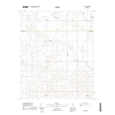
2018 Map of Cadaretta
USGS Topo · Published 2018About this map
Sabougla Creek and its many tributaries, including Lindsay Cr and Pryor Cr, carve through this section of the Mississippi hill country along the border of Calhoun and Webster Counties. The landscape is defined by its rural density, centered on the small communities of Slate Springs, Dentontown, and Cadaretta. Genealogists will find a wealth of local history preserved in the numerous family and community burial grounds scattered across the townships, such as Pittman Cem, Philadelphia Cem, and Roberts Cem. The terrain rises toward distinctive high points like Sandy Mtn and Bold Hill, while a network of rural routes, including Cadaretta Rd and Dentontown Rd, connects these remote settlements and their historic homesteads.
Find a feature on this map
61 named features on this map. Tap any name to fly to it.
Don’t see what you’re looking for? This feature index may not catch every label — zoom into the map to look around manually.
Map Details
Editions of this 2018 Cadaretta Map
This is the sole edition of this map. No revisions or reprints were ever made.
Other maps of this area

1953 · Walthall
USGS Topo · 1:62,500

1953 · West Point
USGS Topo · 1:250,000

1954 · Pittsboro
USGS Topo · 1:62,500

1954 · Duck Hill
USGS Topo · 1:62,500

1955 · Coffeeville
USGS Topo · 1:62,500

1958 · West Point
USGS Topo · 1:250,000

1963 · West Point
USGS Topo · 1:250,000
1976 · Pittsboro SE
USGS Topo · 1:24,000
1976 · Walthall SE
USGS Topo · 1:24,000
1976 · Walthall NE
USGS Topo · 1:24,000