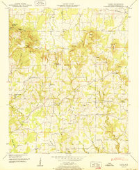
1950 Map of Caddo
USGS Topo · Published 1950About this map
The rugged topography of eastern Lawrence County is defined by a series of steep ridges and creek bottoms, including Chicken Foot Mountain and Bates Mountain. In 1950, this area remained largely rural, characterized by scattered family settlements and a network of country churches like New Antioch Ch and Sulphur Springs Church. The landscape is dotted with numerous springs and caves, such as Ivy Hollow Cave and the curiously named Penitentiary Hole.
Find a feature on this map
87 named features on this map. Tap any name to fly to it.
Don’t see what you’re looking for? This feature index may not catch every label — zoom into the map to look around manually.
Map Details
Editions of this 1950 Caddo Map
2 editions found
Other maps of this area

1935 · Moulton
USGS Topo · 1:24,000

1935 · Danville
USGS Topo · 1:48,000

1935 · Oakville
USGS Topo · 1:24,000

1936 · Caddo
USGS Topo · 1:24,000

1936 · Stewart Cross Roads
USGS Topo · 1:24,000

1936 · Courtland
USGS Topo · 1:24,000

1936 · Trinity
USGS Topo · 1:24,000

1936 · Hillsboro
USGS Topo · 1:24,000

1936 · Moulton
USGS Topo · 1:48,000

1936 · Masterson
USGS Topo · 1:24,000