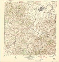
1946 Map of Caguas
USGS Topo · Published 1946About this map
The valley city of Caguas serves as the focal point for this mid-1940s survey, showing a landscape defined by industrial sugar processing and a network of mountain settlements. The Central Santa Juana and Central Defensa facilities mark the importance of the sugar industry at the confluence of the Rio Grande de Loiza and its tributaries. Steep terrain rises sharply from the basin toward Cerro Las Piñas and Los Sumideros, where narrow roads connect rural hamlets like Las Cruces and La Rampa. A detailed spiritual and educational infrastructure is evident through the many dispersed chapels, including Capilla San Patricio and Capilla del San Alfonso, alongside the Escuela Segunda Unidad de Turabo. This edition provides a clear record of the region’s topography before the rapid urbanization that would later transform the area surrounding the Turabo district.
Find a feature on this map
42 named features on this map. Tap any name to fly to it.
Don’t see what you’re looking for? This feature index may not catch every label — zoom into the map to look around manually.
Map Details
Editions of this 1946 Caguas Map
2 editions found
Other maps of this area

1946 · Patillas
USGS Topo · 1:30,000

1946 · Aguas Buenas
USGS Topo · 1:30,000

1946 · Cayey
USGS Topo · 1:30,000

1946 · Comerio
USGS Topo · 1:30,000

1946 · Naranjito
USGS Topo · 1:30,000

1946 · Gurabo
USGS Topo · 1:30,000

1946 · Juncos
USGS Topo · 1:30,000

1946 · Yabucoa
USGS Topo · 1:30,000

1946 · Caguas
USGS Topo · 1:30,000
1947 · Caguas NE
USGS Topo · 1:10,000
Featured Places
- Caguas
- Sector Héctor Rivera, Caguas
- Comunidad Hacienda Ramonita, Caguas
- Sector Cano Rivera, Caguas
- Sector Capilla Sagrada Familia, Caguas