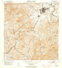
1952 Map of Caguas
USGS Topo · Published 1953About this map
Caguas serves as the focal point of this 1952 topographic survey, depicting the municipality during a period of transition between its agrarian roots and growing urban presence. The influence of the sugar industry is clearly visible with the presence of Central Santa Juana and Central Defensa, indicating the economic importance of sugarcane processing in the Rio Grande de Loiza basin. Modern infrastructure of the era is represented by the Antena de Radio WVJP and the Tanque de Alcantarillado near the town center.
Find a feature on this map
71 named features on this map. Tap any name to fly to it.
Don’t see what you’re looking for? This feature index may not catch every label — zoom into the map to look around manually.
Map Details
Editions of this 1952 Caguas Map
2 editions found
Other maps of this area

1946 · Patillas
USGS Topo · 1:30,000

1946 · Aguas Buenas
USGS Topo · 1:30,000

1946 · Cayey
USGS Topo · 1:30,000

1946 · Comerio
USGS Topo · 1:30,000

1946 · Naranjito
USGS Topo · 1:30,000

1946 · Gurabo
USGS Topo · 1:30,000

1946 · Juncos
USGS Topo · 1:30,000

1946 · Yabucoa
USGS Topo · 1:30,000

1946 · Caguas
USGS Topo · 1:30,000
1947 · Caguas NE
USGS Topo · 1:10,000
Featured Places
- Caguas
- Sector Doña Munda, Caguas
- Sector Almena, Aguas Buenas
- Sector Turabo Abajo, Caguas
- Sector Benito Guzmán, Caguas