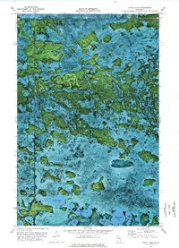
1973 Map of Cahill Lake
USGS Topo · Published 1976About this map
The Red Lake Indian Reservation dominates this orthophotomap, showing a complex mosaic of wetlands and timbered high ground in northern Minnesota. Based on 1969 aerial photography, the map reveals a landscape defined by an intricate network of bogs and small basins, illustrating the saturated terrain that required the use of a Winter Trail for seasonal access. This specific route cuts across the southern portion of the quadrangle, passing through the border of Beltrami Co and Clearwater Co. To the south, a cluster of named water bodies including Cahill Lake, Miskogineu Lake, and Roosevelt Lake provide clear landmarks within the dense vegetation. The orthophoto format provides a direct visual of the varying forest density and water levels as they existed in the early 1970s, offering a precise view of the region's natural hydrology before modern developments.
Find a feature on this map
10 named features on this map. Tap any name to fly to it.
Don’t see what you’re looking for? This feature index may not catch every label — zoom into the map to look around manually.
Map Details
Editions of this 1973 Cahill Lake Map
This is the sole edition of this map. No revisions or reprints were ever made.
Other maps of this area

1918 · Jelle
USGS Topo · 1:62,500

1919 · Churnes
USGS Topo · 1:62,500

1919 · Winsor
USGS Topo · 1:62,500

1954 · Bemidji
USGS Topo · 1:250,000

1954 · Roseau
USGS Topo · 1:250,000

1957 · Roseau
USGS Topo · 1:250,000

1957 · Bemidji
USGS Topo · 1:250,000

1958 · Bemidji
USGS Topo · 1:250,000

1958 · Roseau
USGS Topo · 1:250,000
1972 · Berner NE
USGS Topo · 1:24,000