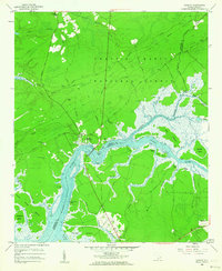
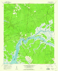
1958 Map of Cainhoy
USGS Topo · Published 1964About this map
The Wando River dominates this lowcountry landscape, carving a complex network of marshes and tidal creeks through the heart of the Francis Marion National Forest. During the late 1950s, the settlement at Cainhoy (Wando PO) served as a central point for the surrounding rural communities, connected to the western bank by the Wando Bridge and further north by the historic Ferry crossing at Clements Ferry Road. The map reveals a deep religious and social history through its numerous rural sanctuaries, including St Thomas Ch, St Pauls Ch, and Charity Ch. This river-dependent economy is evident in the transition from dense forest to the scattered islands like Cat Island and Paradise Island, where the terrain begins to break into the coastal estuaries near the Berkeley and Charleston county line.
Find a feature on this map
53 named features on this map. Tap any name to fly to it.
Don’t see what you’re looking for? This feature index may not catch every label — zoom into the map to look around manually.
Map Details
Editions of this 1958 Cainhoy Map
3 editions found

Other maps of this area

1919 · Capers Island
USGS Topo · 1:21,120

1919 · Wando
USGS Topo · 1:21,120

1919 · Cordesville
USGS Topo · 1:48,000

1919 · Melgrove
USGS Topo · 1:21,120

1919 · Charleston
USGS Topo · 1:21,120

1919 · Fort Moultrie
USGS Topo · 1:21,120

1919 · Sewee Bay
USGS Topo · 1:21,120

1940 · Melgrove
USGS Topo · 1:24,000

1943 · Capers Island
USGS Topo · 1:24,000

1943 · Fort Moultrie
USGS Topo · 1:24,000