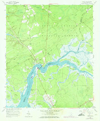
1958 Map of Cainhoy
USGS Topo · Published 1973About this map
Francis Marion National Forest dominates the upper half of this lowcountry landscape, where narrow roadways like Brick Church Rd and Old House Motorway weave through a terrain defined by wetlands and creek drainages. The Wando River serves as the central artery, separating Berkeley and Charleston counties. Along its banks, the settlement of Cainhoy and the nearby Wando community appear at a time when the Wando Bridge provided critical connectivity across the water.
Find a feature on this map
57 named features on this map. Tap any name to fly to it.
Don’t see what you’re looking for? This feature index may not catch every label — zoom into the map to look around manually.
Map Details
Editions of this 1958 Cainhoy Map
3 editions found
Other maps of this area

1919 · Capers Island
USGS Topo · 1:21,120

1919 · Wando
USGS Topo · 1:21,120

1919 · Cordesville
USGS Topo · 1:48,000

1919 · Melgrove
USGS Topo · 1:21,120

1919 · Charleston
USGS Topo · 1:21,120

1919 · Fort Moultrie
USGS Topo · 1:21,120

1919 · Sewee Bay
USGS Topo · 1:21,120

1940 · Melgrove
USGS Topo · 1:24,000

1943 · Capers Island
USGS Topo · 1:24,000

1943 · Fort Moultrie
USGS Topo · 1:24,000