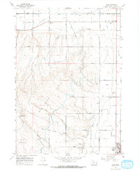
1967 Map of Cairo
USGS Topo · Published 1971About this map
Malheur Butte dominates the northern horizon of this eastern Oregon landscape, standing as a prominent landmark near the intersection of the Malheur Union Pacific Canal and the Union Pacific railroad. The 1960s irrigation network is strikingly complex, featuring the Sheep Creek Siphon, Owyhee Ditch, and the Malheur Siphon Drive, illustrating the heavy engineering required to support agriculture across Big Sage Flats. Small rural hubs like Cairo Junction and Mallett serve the surrounding farmsteads, anchored by local institutions such as the Cairo Sch, Malheur Butte Ch, and a Grange Hall. Further south, the map details the residential and civic fringes of Nyssa, including the Nyssa Cem and the local High Sch, providing a clear record of the area's mid-century development and water management infrastructure.
Find a feature on this map
52 named features on this map. Tap any name to fly to it.
Don’t see what you’re looking for? This feature index may not catch every label — zoom into the map to look around manually.
Map Details
Editions of this 1967 Cairo Map
This is the sole edition of this map. No revisions or reprints were ever made.
Other maps of this area

1897 · Weiser
USGS Topo · 1:125,000

1898 · Nampa
USGS Topo · 1:125,000

1906 · Mitchell Butte
USGS Topo · 1:125,000

1951 · Malheur Butte
USGS Topo · 1:24,000

1951 · Moores Hollow
USGS Topo · 1:62,500

1951 · Payette
USGS Topo · 1:24,000

1955 · Baker
USGS Topo · 1:250,000

1955 · Boise
USGS Topo · 1:250,000

1958 · Boise
USGS Topo · 1:250,000

1959 · Baker
USGS Topo · 1:250,000