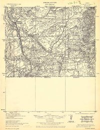
1933 Map of Calabasas
USGS Topo · Published 1933About this map
Nogales anchors this tactical survey along the international boundary, a decade after the 1916 and 1922 revisions. The map details a landscape defined by the Santa Cruz River and the Southern Pacific rail line, showing the town's growth alongside military installations like Camp Stephen D. Little and its adjacent Target Range. Beyond the urban center, a network of cattle ranches and mining claims spreads through the canyons of the Coronado National Forest. Distinctive landmarks such as the Calabasas Store, Hotel Esplendor, and the Monte Carlo Dairy provide a granular view of the local economy during this era. Large historical land grants, including Baca Float No. 3 and San Jose de Sonoita, remain visible as primary geographic divisions, illustrating the enduring influence of older territorial claims on the 1930s borderland topography.
Find a feature on this map
57 named features on this map. Tap any name to fly to it.
Don’t see what you’re looking for? This feature index may not catch every label — zoom into the map to look around manually.
Map Details
Editions of this 1933 Calabasas Map
2 editions found
Other maps of this area

1904 · Patagonia
USGS Topo · 1:125,000

1905 · Patagonia
USGS Topo · 1:125,000

1905 · Nogales
USGS Topo · 1:125,000

1920 · Arivaca
USGS Topo · 1:125,000

1921 · Old Glory
USGS Topo · 1:125,000

1922 · Agus Caliente
USGS Topo · 1:62,500

1932 · Lochiel
USGS Topo · 1:62,500

1932 · Elgin
USGS Topo · 1:62,500

1933 · Calabasas
USGS Topo · 1:62,500

1939 · Tubac
USGS Topo · 1:62,500