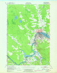
1949 Map of Calais
USGS Topo · Published 1978About this map
The St Croix River serves as the international boundary and central artery for this late 1940s landscape, connecting the industrial history of Calais with its neighbors across the water in St Stephen. The map reveals a dense network of water-dependent settlements and industrial footprints, from the mill sites at Milltown and Union Mills to the specialized landscape of Sawdust Island. To the south, the established grounds of the St Croix Golf Course contrast with the burgeoning protected lands of the Moosehorn National Wildlife Refuge, indicating a shift in land use toward recreation and conservation.
Find a feature on this map
59 named features on this map. Tap any name to fly to it.
Don’t see what you’re looking for? This feature index may not catch every label — zoom into the map to look around manually.
Map Details
Editions of this 1949 Calais Map
3 editions found
Other maps of this area

1929 · Calais
USGS Topo · 1:48,000

1929 · Robbinston
USGS Topo · 1:48,000

1931 · Robbinston
USGS Topo · 1:62,500

1932 · Calais
USGS Topo · 1:62,500

1940 · Kellyland
USGS Topo · 1:62,500

1942 · Kellyland
USGS Topo · 1:62,500

1949 · Calais
USGS Topo · 1:24,000

1949 · Red Beach
USGS Topo · 1:24,000

1949 · Devils Head
USGS Topo · 1:24,000
1954 · Calais
USGS Topo · 1:25,000