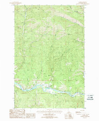
1988 Map of Calder
USGS Topo · Published 1988About this map
Calder serves as the central focal point along the banks of the St Joe River, appearing as a small outpost in the high timber of the St Joe National Forest during the late 1980s. The settlement's infrastructure includes the Calder Ranger Sta, a Heliport, and a Gaging Station monitoring the river's flow. Steep terrain is defined by curiously named landmarks like Billy Goat Hill, Spooky Butte, and Coyote Butte, while the river valley retains the mark of its industrial past with an Old Railroad Grade running parallel to the water. This transit corridor was vital for the region's logging history, connecting isolated drainages such as Trout Creek, Mica Creek, and Charley Creek to larger networks. The landscape is also marked by an extensive system of Pack Trails and Foot Trails that traverse the ridge lines, providing a record of backcountry access through the Bitterroot mountains.
Find a feature on this map
29 named features on this map. Tap any name to fly to it.
Don’t see what you’re looking for? This feature index may not catch every label — zoom into the map to look around manually.
Map Details
Editions of this 1988 Calder Map
This is the sole edition of this map. No revisions or reprints were ever made.
Other maps of this area

1950 · Twin Crags
USGS Topo · 1:24,000

1952 · Twin Crags
USGS Topo · 1:24,000

1955 · Spokane
USGS Topo · 1:250,000

1957 · Calder
USGS Topo · 1:62,500

1957 · St. Joe
USGS Topo · 1:62,500

1958 · Spokane
USGS Topo · 1:250,000

1961 · Fernwood
USGS Topo · 1:62,500

1969 · Marble Mountain
USGS Topo · 1:24,000

1969 · Huckleberry Mtn
USGS Topo · 1:24,000

1981 · St Maries
USGS Topo · 1:100,000