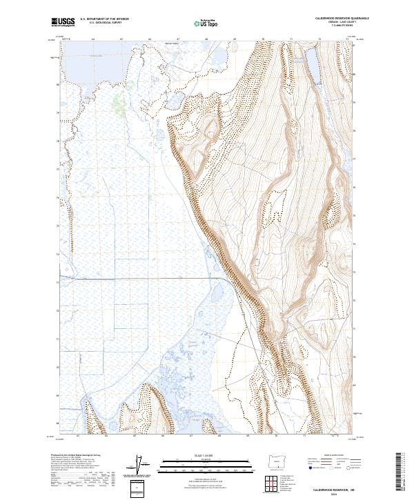
2024 Map of Calderwood Reservoir
USGS Topo · Published 2024About this map
Warner Valley's hydrology dominates this corner of Lake County, where seasonal waters and permanent basins shift across the desert floor. The northern reach is anchored by Crump Lake, while the eastern terrain rises sharply toward the rim overlooking Calderwood Reservoir and Fish Creek. This landscape is defined by the managed movement of water in an arid environment, seen in the strategically placed Greaser Reservoir and the drainage of Deep Creek. The presence of Twentymile Slough and Greaser Lake at the southern end suggests a basin where runoff collects against the high eastern ridges, creating a complex network of wetlands and intermittent flows that have long dictated land use in the high desert.
Find a feature on this map
14 named features on this map. Tap any name to fly to it.
Don’t see what you’re looking for? This feature index may not catch every label — zoom into the map to look around manually.
Map Details
Editions of this 2024 Calderwood Reservoir Map
This is the sole edition of this map. No revisions or reprints were ever made.
Other maps of this area

1955 · Adel
USGS Topo · 1:250,000

1957 · Adel
USGS Topo · 1:250,000

1958 · Adel
USGS Topo · 1:250,000

1962 · Adel
USGS Topo · 1:250,000

1967 · Jacobs Reservoir
USGS Topo · 1:24,000

1967 · Priday Reservoir
USGS Topo · 1:24,000

1967 · Crump Lake
USGS Topo · 1:24,000
1968 · May Lake
USGS Topo · 1:24,000
1968 · Calderwood Reservoir
USGS Topo · 1:24,000
1968 · Coleman Lake
USGS Topo · 1:24,000