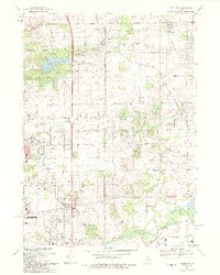
1993 Map of Caledonia
USGS Topo · Published 1993About this map
Caledonia and Argyle anchor the northern reaches of this 1993 map, marking a landscape where the Chicago And North Western railroad corridor meets the sprawling suburban edges of Rockford and Loves Park. The Winnebago and Boone county line bisects a terrain defined by glacial drainage patterns, where Beaver Creek and Spring Creek wind through fields and growing neighborhoods. Genealogy and local history are preserved in sites like the Argyle Cem and the Guilford Union Ch, while the southern portion of the sheet shows the transition into industry and education near Rock Valley College. The development of the Northwest Tollway and the established Kishwaukee River basin illustrate the region's late-century evolution from agricultural prairie to a major transportation and population hub.
Find a feature on this map
73 named features on this map. Tap any name to fly to it.
Don’t see what you’re looking for? This feature index may not catch every label — zoom into the map to look around manually.
Map Details
Editions of this 1993 Caledonia Map
This is the sole edition of this map. No revisions or reprints were ever made.
Other maps of this area

1917 · Kings
USGS Topo · 1:62,500

1918 · Rockford
USGS Topo · 1:62,500

1918 · Belvidere
USGS Topo · 1:62,500

1918 · Kings
USGS Topo · 1:62,500

1918 · Kirkland
USGS Topo · 1:62,500

1938 · Rockford
USGS Topo · 1:62,500

1944 · Belvidere
USGS Topo · 1:62,500

1949 · Camp Grant
USGS Topo · 1:24,000

1949 · Rockford
USGS Topo · 1:24,000

1954 · Rockford
USGS Topo · 1:250,000