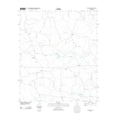
2013 Map of Caledonia
USGS Topo · Published 2013About this map
The Attoyac River carves a winding path through this corner of Rusk County, anchoring a landscape defined by small rural settlements and family burial grounds. Local history is deeply embedded in the numerous cemeteries scattered across the terrain, including Hall Cem, Whitfield Cem, and Langston Spence Cem, which offer significant value for genealogists tracing regional family roots. The settlement pattern is relatively dispersed, with Lawsonville, Caledonia, and Concord serving as central points connected by a network of farm-to-market roads and county routes.
Find a feature on this map
76 named features on this map. Tap any name to fly to it.
Don’t see what you’re looking for? This feature index may not catch every label — zoom into the map to look around manually.
Map Details
Editions of this 2013 Caledonia Map
This is the sole edition of this map. No revisions or reprints were ever made.
Other maps of this area

1953 · Palestine
USGS Topo · 1:250,000

1956 · Tyler
USGS Topo · 1:250,000

1957 · Palestine
USGS Topo · 1:250,000

1958 · Timpson
USGS Topo · 1:62,500

1958 · Carthage
USGS Topo · 1:62,500

1960 · Minden
USGS Topo · 1:62,500

1960 · Mount Enterprise
USGS Topo · 1:62,500

1983 · Long Branch
USGS Topo · 1:24,000
1983 · Minden
USGS Topo · 1:24,000
1983 · Lake Murvaul
USGS Topo · 1:24,000