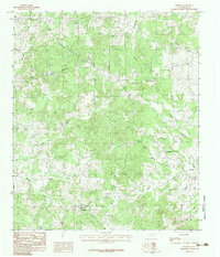
1983 Map of Minden
USGS Topo · Published 1983About this map
Minden and Brachfield serve as the primary hubs in this part of Rusk County, reflecting a rural Texas landscape defined by an intricate network of creeks and bayous. In the early 1980s, the terrain is characterized by its numerous watercourses, including the prominent Murvaul Bayou and smaller tributaries like Jarrell Creek and Owens Creek. The presence of Walker Lake and a designated Boat Shed suggests a reliance on local water bodies for recreation or small-scale industry. Scattered residences and family-named features like Maxwell and Welch Springs Branch reveal a long-standing pattern of settlement along these drainage systems. The inclusion of Winfrey Ditch indicates early modifications to the natural drainage, while the various branches—from Barnhardt Creek to Mc Cann Branch—point to the complex hydrology that influenced land use and property boundaries in this East Texas region.
Find a feature on this map
18 named features on this map. Tap any name to fly to it.
Don’t see what you’re looking for? This feature index may not catch every label — zoom into the map to look around manually.
Map Details
Editions of this 1983 Minden Map
This is the sole edition of this map. No revisions or reprints were ever made.
Other maps of this area

1935 · Henderson
USGS Topo · 1:48,000

1939 · Henderson
USGS Topo · 1:62,500

1943 · Cushing
USGS Topo · 1:62,500

1945 · Cushing
USGS Topo · 1:62,500

1953 · Palestine
USGS Topo · 1:250,000

1956 · Tyler
USGS Topo · 1:250,000

1957 · Palestine
USGS Topo · 1:250,000

1960 · Minden
USGS Topo · 1:62,500

1960 · Mount Enterprise
USGS Topo · 1:62,500

1973 · Henderson
USGS Topo · 1:24,000