
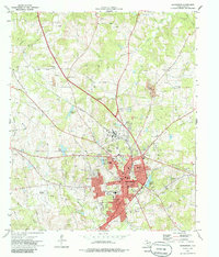
1973 Map of Henderson
USGS Topo · Published 1975About this map
Henderson serves as the focal point of this Rusk County study, appearing at a moment of significant mid-century growth and industrial activity. The landscape is characterized by a dense network of energy infrastructure, including a prominent Refinery and numerous gas wells that punctuate the terrain alongside the Missouri Pacific railroad line. Residential expansion is visible in neighborhoods like Crimcrest and Lake View, while the local social fabric is traced through several schools such as Montgomery Sch and Central Sch, and a notable concentration of family and community cemeteries including Thomas Cem and Mizner Sch Cem.
Find a feature on this map
52 named features on this map. Tap any name to fly to it.
Don’t see what you’re looking for? This feature index may not catch every label — zoom into the map to look around manually.
Map Details
Editions of this 1973 Henderson Map
2 editions found
Other maps of this area

1935 · Henderson
USGS Topo · 1:48,000

1936 · Kilgore
USGS Topo · 1:48,000

1939 · Henderson
USGS Topo · 1:62,500

1940 · Kilgore
USGS Topo · 1:62,500

1956 · Tyler
USGS Topo · 1:250,000

1958 · Tatum
USGS Topo · 1:62,500

1960 · Minden
USGS Topo · 1:62,500
1971 · Kilgore SW
USGS Topo · 1:24,000
1971 · Kilgore SE
USGS Topo · 1:24,000
1973 · Berryhill Creek
USGS Topo · 1:24,000