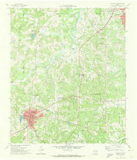
1971 Map of Kilgore SW
USGS Topo · Published 1974About this map
Overton serves as a primary hub in this East Texas landscape, where the confluence of the Missouri Pacific railroad and localized industrial infrastructure defines the region's character. The map documents an area deeply integrated with the petroleum and agricultural sectors, as evidenced by the Gas Plant and Refinery near Kilgore, and the academic influence of the Kilgore College Demonstration Farm and the Texas A and M Research Center.
Find a feature on this map
51 named features on this map. Tap any name to fly to it.
Don’t see what you’re looking for? This feature index may not catch every label — zoom into the map to look around manually.
Map Details
Editions of this 1971 Kilgore SW Map
This is the sole edition of this map. No revisions or reprints were ever made.
Other maps of this area

1935 · Henderson
USGS Topo · 1:48,000

1936 · Kilgore
USGS Topo · 1:48,000

1937 · Troupe
USGS Topo · 1:48,000

1938 · Winona
USGS Topo · 1:48,000

1939 · Henderson
USGS Topo · 1:62,500

1940 · Kilgore
USGS Topo · 1:62,500

1943 · Troup
USGS Topo · 1:62,500

1943 · Winona
USGS Topo · 1:62,500

1956 · Tyler
USGS Topo · 1:250,000

1966 · Hope Pond
USGS Topo · 1:24,000