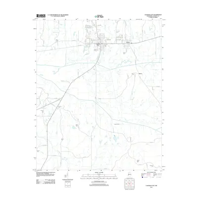
2012 Map of Calhoun City
USGS Topo · Published 2012About this map
Calhoun City and the neighboring community of Derma anchor this northern Mississippi landscape, where the Yalobusha River and its tributaries carve through the countryside. The area is defined by a high density of small rural burial grounds, providing a significant resource for genealogists researching families around the Benela settlement. These sites, such as New Gauley Cem, Friendship Cem, and McPhail Cem, are scattered across the terrain, often near small watercourses like Hurricane Cr and Splunge Cr. In the southern portion of the map, Rainbow Field and Pleasant Ridge Cem mark the transition toward more open bottoms, while the northern section shows the established street grids of the primary towns. The network of local routes, including Co RD 306 and Co RD 308, connects these historic centers with the surrounding agricultural land and water bodies like Martin Lakes.
Find a feature on this map
89 named features on this map. Tap any name to fly to it.
Don’t see what you’re looking for? This feature index may not catch every label — zoom into the map to look around manually.
Map Details
Editions of this 2012 Calhoun City Map
This is the sole edition of this map. No revisions or reprints were ever made.
Other maps of this area

1953 · Walthall
USGS Topo · 1:62,500

1953 · West Point
USGS Topo · 1:250,000

1954 · Pittsboro
USGS Topo · 1:62,500

1958 · West Point
USGS Topo · 1:250,000

1963 · West Point
USGS Topo · 1:250,000

1972 · Atlanta
USGS Topo · 1:24,000

1972 · Vardaman
USGS Topo · 1:24,000

1972 · Hohenlinden
USGS Topo · 1:24,000
1976 · Pittsboro SE
USGS Topo · 1:24,000
1976 · Pittsboro NE
USGS Topo · 1:24,000