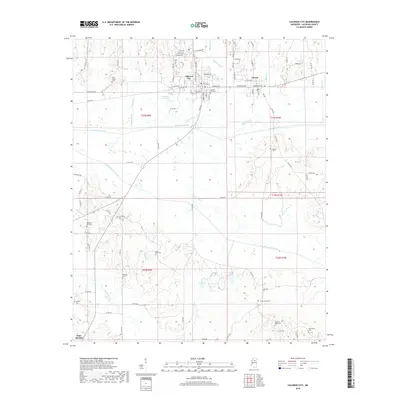
2018 Map of Calhoun City
USGS Topo · Published 2018About this map
Calhoun City and Derma serve as the primary population centers in this rural Mississippi landscape, situated north of the expansive Shipp Bottom floodplains. The drainage of the Yalobusha River and its numerous tributaries, such as Topashaw Cr and Hurricane Cr, defines the local topography. This 2018 survey reveals a settlement pattern characterized by numerous small, family-oriented burial grounds scattered throughout the countryside, including New Gauley Cem, Cross Road Cem, and Pleasant Ridge Cem. To the south, Slate Springs sits near the confluence of Shutispear Cr and the larger Topashaw Creek Canal. This network of waterways and canals illustrates the region's historic efforts to manage the wetlands and bottomlands for agriculture and development.
Find a feature on this map
98 named features on this map. Tap any name to fly to it.
Don’t see what you’re looking for? This feature index may not catch every label — zoom into the map to look around manually.
Map Details
Editions of this 2018 Calhoun City Map
This is the sole edition of this map. No revisions or reprints were ever made.
Other maps of this area

1953 · Walthall
USGS Topo · 1:62,500

1953 · West Point
USGS Topo · 1:250,000

1954 · Pittsboro
USGS Topo · 1:62,500

1958 · West Point
USGS Topo · 1:250,000

1963 · West Point
USGS Topo · 1:250,000

1972 · Atlanta
USGS Topo · 1:24,000

1972 · Vardaman
USGS Topo · 1:24,000

1972 · Hohenlinden
USGS Topo · 1:24,000
1976 · Pittsboro SE
USGS Topo · 1:24,000
1976 · Pittsboro NE
USGS Topo · 1:24,000