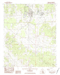
1983 Map of Calhoun City
USGS Topo · Published 1984About this map
The Old Indian Treaty Boundary slices across this Mississippi landscape, providing a historical anchor for the local geography of Calhoun City and Derma. This survey captures the region's complex hydrology, dominated by the Yalobusha River and the meandering Topashaw Creek, which dictate the placement of transportation routes and agricultural land. The map reveals a dense network of local landmarks essential for genealogical research, including New Gauley Ch, Reedy Chapel, and several family and community burial grounds such as Cross Road Cem and Morland Cem. To the south, the village of Slate Spring serves as a small rural hub, while features like the Hardin Landing Strip indicate the area's mid-century aviation infrastructure. The transition from the river bottomlands to the surrounding hills is marked by numerous churches and cemeteries that have defined these communities for generations.
Find a feature on this map
31 named features on this map. Tap any name to fly to it.
Don’t see what you’re looking for? This feature index may not catch every label — zoom into the map to look around manually.
Map Details
Editions of this 1983 Calhoun City Map
This is the sole edition of this map. No revisions or reprints were ever made.
Other maps of this area

1953 · Walthall
USGS Topo · 1:62,500

1953 · West Point
USGS Topo · 1:250,000

1954 · Pittsboro
USGS Topo · 1:62,500

1958 · West Point
USGS Topo · 1:250,000

1963 · West Point
USGS Topo · 1:250,000

1972 · Atlanta
USGS Topo · 1:24,000

1972 · Vardaman
USGS Topo · 1:24,000

1972 · Hohenlinden
USGS Topo · 1:24,000
1976 · Pittsboro SE
USGS Topo · 1:24,000
1976 · Pittsboro NE
USGS Topo · 1:24,000