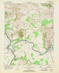
1952 Map of Calhoun
USGS Topo · Published 1970About this map
The Green River carves a deep, winding path through McLean County in the early 1950s, serving as a primary corridor for commerce and transportation. The presence of Lock No 2 and a Gaging Sta at the settlement of Calhoun highlights the river's managed flow, essential for the area's river-driven economy. Opposite the county seat, the community of Rumsey sits near the riverbanks, while smaller hamlets like Ashbyburg and Jewel City mark the junctions of local roads and waterways.
Find a feature on this map
27 named features on this map. Tap any name to fly to it.
Don’t see what you’re looking for? This feature index may not catch every label — zoom into the map to look around manually.
Map Details
Editions of this 1952 Calhoun Map
Other maps of this area

1906 · Sutherland
USGS Topo · 1:62,500

1908 · Calhoun
USGS Topo · 1:62,500

1909 · Madisonville
USGS Topo · 1:62,500

1909 · Central City
USGS Topo · 1:62,500

1952 · Livermore
USGS Topo · 1:24,000

1952 · Sacramento
USGS Topo · 1:24,000

1952 · Calhoun
USGS Topo · 1:24,000

1952 · Beech Grove
USGS Topo · 1:24,000

1952 · Hanson
USGS Topo · 1:24,000
1953 · Glenville
USGS Topo · 1:24,000