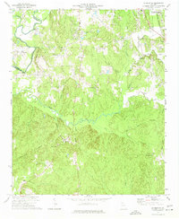
1972 Map of Calhoun NE
USGS Topo · Published 1974About this map
The Conasauga River winds through the western portion of this 1972 survey, defining the border between Murray and Whitfield counties. This rural landscape is characterized by a high density of community landmarks, particularly country churches such as Smyrna Ch, New Hope Ch, and Maranatha Ch. The presence of Timms Chapel and Hall Ground Ch alongside family-named burial sites like Kilgore Cem indicates a long-settled agricultural region.
Find a feature on this map
47 named features on this map. Tap any name to fly to it.
Don’t see what you’re looking for? This feature index may not catch every label — zoom into the map to look around manually.
Map Details
Editions of this 1972 Calhoun NE Map
3 editions found
Other maps of this area

1886 · Dalton
USGS Topo · 1:125,000

1892 · Dalton
USGS Topo · 1:125,000

1897 · Dalton
USGS Topo · 1:125,000

1911 · Cohutta Mtn
USGS Topo · 1:62,500

1913 · Cohutta Mtn.
USGS Topo · 1:62,500

1914 · Talking Rock
USGS Topo · 1:62,500

1916 · Talking Rock
USGS Topo · 1:62,500

1938 · Chatsworth
USGS Topo · 1:48,000

1943 · Dalton
USGS Topo · 1:62,500
1949 · Calhoun
USGS Topo · 1:62,500