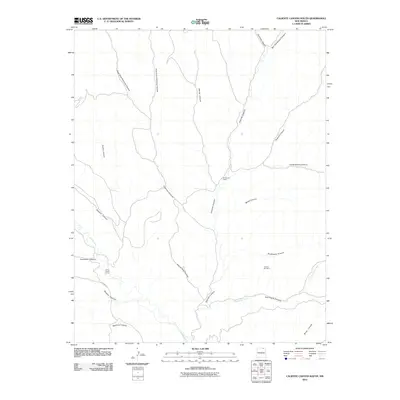
2010 Map of Caliente Canyon South
USGS Topo · Published 2010About this map
Caliente Canyon and its complex network of tributaries define this Colfax County landscape, where the high desert terrain of northern New Mexico is etched by deep drainage systems. The Vermejo River cuts through the southwestern corner, joined by the rugged paths of Gachupin Canyon and Speilman Canyon. These geographic features are marked by working land use, evidenced by the presence of W S Ranch Camp and Horse Ranch Camp.
Find a feature on this map
25 named features on this map. Tap any name to fly to it.
Don’t see what you’re looking for? This feature index may not catch every label — zoom into the map to look around manually.
Map Details
Editions of this 2010 Caliente Canyon South Map
This is the sole edition of this map. No revisions or reprints were ever made.
Other maps of this area

1915 · Brilliant
USGS Topo · 1:62,500

1915 · Koehler
USGS Topo · 1:62,500

1917 · Koehler
USGS Topo · 1:62,500

1954 · Raton
USGS Topo · 1:250,000

1955 · Cimarron
USGS Topo · 1:62,500

1958 · Raton
USGS Topo · 1:250,000

1962 · Casa Grande
USGS Topo · 1:62,500

1971 · Saltpeter Mountain
USGS Topo · 1:24,000
1971 · Curtis Camp
USGS Topo · 1:24,000
1971 · Mc Williams Canyon
USGS Topo · 1:24,000