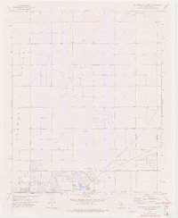
1973 Map of California City North
USGS Topo · Published 1976About this map
The sprawling planned layout of California City dominates the southern portion of this desert landscape, showing an ambitious network of residential streets and boulevards carved into the Fremont Valley. While the southern core features developed sites like Central Park, many of the northern reaches appear as surveyed road alignments waiting for growth, such as Mendiburu Road and Lindbergh Blvd. To the north and east, the terrain rises into the Rand Mountains, contrasting the flat valley floor where Cache Creek periodically flows.
Find a feature on this map
32 named features on this map. Tap any name to fly to it.
Don’t see what you’re looking for? This feature index may not catch every label — zoom into the map to look around manually.
Map Details
Editions of this 1973 California City North Map
2 editions found
Other maps of this area

1915 · Searles Lake
USGS Topo · 1:250,000

1915 · Mojave
USGS Topo · 1:125,000

1943 · Cross Mountain
USGS Topo · 1:62,500

1943 · Saltdale
USGS Topo · 1:62,500

1943 · Castle Butte
USGS Topo · 1:62,500

1943 · Mojave
USGS Topo · 1:62,500

1947 · Castle Butte
USGS Topo · 1:50,000

1947 · Plano
USGS Topo · 1:24,000

1947 · Desert Butte
USGS Topo · 1:24,000
1947 · Castle Butte SE
USGS Topo · 1:24,000