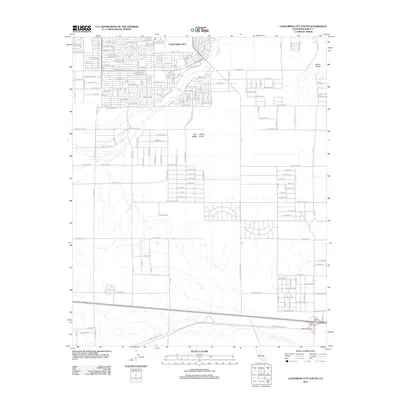
2012 Map of California City South
USGS Topo · Published 2012About this map
California City sprawls across the northern portion of this Mojave Desert landscape, characterized by its expansive and ambitious grid of residential streets like 73rd St and 110th St. This planned community reflects mid-century urban design where a vast network of named roads was established across the high desert long before dense development. To the south, the industrial and military importance of the region is evident with the presence of the Edwards Air Force Sta. Transport infrastructure is anchored by the railroad line in the southern portion of the quadrangle, featuring the Muroc Junction and Edwards Siding. The natural terrain is punctuated by distinctive landforms such as Castle Butte, Twin Buttes, and Desert Butte, while the seasonal Cache Cr carves a path through the northern residential sectors. This survey provides a precise look at the intersection of desert topography and modern aviation-related development.
Find a feature on this map
168 named features on this map. Tap any name to fly to it.
Don’t see what you’re looking for? This feature index may not catch every label — zoom into the map to look around manually.
Map Details
Editions of this 2012 California City South Map
This is the sole edition of this map. No revisions or reprints were ever made.
Other maps of this area

1915 · Elizabeth Lake
USGS Topo · 1:125,000

1915 · Searles Lake
USGS Topo · 1:250,000

1915 · Mojave
USGS Topo · 1:125,000

1917 · Elizabeth Lake
USGS Topo · 1:125,000

1937 · Rogers Lake
USGS Topo · 1:48,000

1942 · Rogers Lake
USGS Topo · 1:62,500

1943 · Rosamond
USGS Topo · 1:62,500

1943 · Castle Butte
USGS Topo · 1:62,500

1943 · Mojave
USGS Topo · 1:62,500

1947 · Fluhr
USGS Topo · 1:24,000