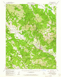
1959 Map of Calistoga
USGS Topo · Published 1962About this map
Calistoga serves as the focal point of this northern Napa Valley landscape, where the Napa River flows through a corridor of early viticulture and industry. The map documents a significant era of preservation and history, featuring the Robert Louis Stevenson Memorial State Park and the Bale Mill Historical Monument. The industrial character of the Mayacamas Mountains is clearly visible through an extensive network of quicksilver and mineral operations, including the Oat Hill Extension Mine, Mirabel Mine, and Helen Mine.
Find a feature on this map
188 named features on this map. Tap any name to fly to it.
Don’t see what you’re looking for? This feature index may not catch every label — zoom into the map to look around manually.
Map Details
Editions of this 1959 Calistoga Map
2 editions found
Other maps of this area

1902 · Napa
USGS Topo · 1:125,000

1916 · Santa Rosa
USGS Topo · 1:62,500

1920 · Healdsburg
USGS Topo · 1:62,500

1921 · Kelseyville
USGS Topo · 1:62,500

1927 · Calistoga
USGS Topo · 1:62,500

1933 · Healdsburg
USGS Topo · 1:48,000

1935 · Sebastopol
USGS Topo · 1:48,000

1940 · Healdsburg
USGS Topo · 1:62,500

1942 · Sebastopol
USGS Topo · 1:62,500

1942 · Sonoma
USGS Topo · 1:62,500