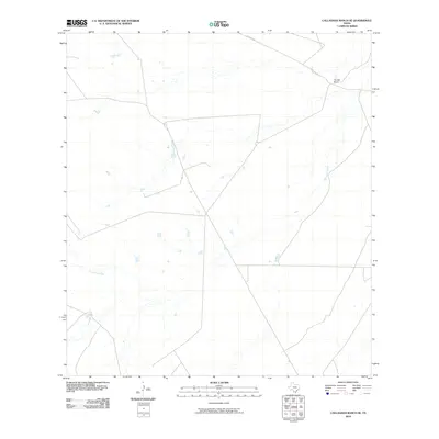
2010 Map of Callaghan Ranch SE
USGS Topo · Published 2010About this map
Carrizitos Creek winds through this South Texas landscape, defining the local drainage patterns across a sparsely populated expanse of Webb County. The presence of The Old Ranch in the northeastern corner suggests a legacy of traditional cattle ranching in a region where large landholdings are common. Transportation across this arid terrain is facilitated by Becerras Rd, which cuts across the upper portion of the quadrangle. The map reflects a modern inventory of the area's hydrology and land use, capturing the subtle network of stock tanks and seasonal drainages that sustain the ranching economy. This 2010 survey by the U.S. Geological Survey provides a precise look at the rural infrastructure and natural features of the Texas brush country before more intensive industrial or energy-related developments altered the surface landscape.
Find a feature on this map
3 named features on this map. Tap any name to fly to it.
Don’t see what you’re looking for? This feature index may not catch every label — zoom into the map to look around manually.
Map Details
Editions of this 2010 Callaghan Ranch SE Map
This is the sole edition of this map. No revisions or reprints were ever made.
Other maps of this area

1937 · Aguilete Creek
USGS Topo · 1:62,500

1956 · Becerra
USGS Topo · 1:62,500

1956 · Laredo East
USGS Topo · 1:62,500

1956 · Webb
USGS Topo · 1:62,500

1956 · Laredo
USGS Topo · 1:250,000

1965 · Orvil
USGS Topo · 1:24,000

1965 · Cibolo Ranch
USGS Topo · 1:24,000
1980 · Callaghan Ranch SE
USGS Topo · 1:24,000
1980 · Venado Creek West
USGS Topo · 1:24,000
1980 · Piedra Parada Tank
USGS Topo · 1:24,000