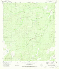
1980 Map of Callaghan Ranch SE
USGS Topo · Published 1980About this map
The arid landscape of Webb County is defined by intermittent drainage and specialized ranching infrastructure in this early 1980s topographical study. Carrizitos Creek winds through the southern and eastern portions of the quadrangle, serving as a primary geographical anchor for the surrounding terrain. Human activity is concentrated around scattered resources, most notably at the site labeled The Old Ranch in the northeast.
Find a feature on this map
7 named features on this map. Tap any name to fly to it.
Don’t see what you’re looking for? This feature index may not catch every label — zoom into the map to look around manually.
Map Details
Editions of this 1980 Callaghan Ranch SE Map
This is the sole edition of this map. No revisions or reprints were ever made.
Other maps of this area

1937 · Aguilete Creek
USGS Topo · 1:62,500

1956 · Becerra
USGS Topo · 1:62,500

1956 · Laredo East
USGS Topo · 1:62,500

1956 · Webb
USGS Topo · 1:62,500

1956 · Laredo
USGS Topo · 1:250,000

1965 · Orvil
USGS Topo · 1:24,000

1965 · Cibolo Ranch
USGS Topo · 1:24,000
1980 · Venado Creek West
USGS Topo · 1:24,000
1980 · Piedra Parada Tank
USGS Topo · 1:24,000
1980 · Callaghan Ranch South
USGS Topo · 1:24,000