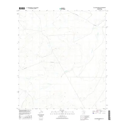
2016 Map of Callaghan Ranch SE
USGS Topo · Published 2016About this map
Carrizitos Cr winds through this segment of Webb County, defining the drainage patterns of a landscape managed for large-scale ranching. The terrain is crossed by a handful of established corridors, notably Callaghan Rd and Ranch Rd 6178A, which facilitate movement through this brush-covered portion of South Texas. As part of the broader Callaghan Ranch SE area, the map illustrates the spatial relationship between seasonal watercourses and the infrastructure required for land management in the 21st century. The sparse naming of features reflects the vast, privately-held nature of the region, where roads and creeks remain the primary identifiers for local navigation and property orientation.
Find a feature on this map
3 named features on this map. Tap any name to fly to it.
Don’t see what you’re looking for? This feature index may not catch every label — zoom into the map to look around manually.
Map Details
Editions of this 2016 Callaghan Ranch SE Map
This is the sole edition of this map. No revisions or reprints were ever made.
Other maps of this area

1937 · Aguilete Creek
USGS Topo · 1:62,500

1956 · Becerra
USGS Topo · 1:62,500

1956 · Laredo East
USGS Topo · 1:62,500

1956 · Webb
USGS Topo · 1:62,500

1956 · Laredo
USGS Topo · 1:250,000

1965 · Orvil
USGS Topo · 1:24,000

1965 · Cibolo Ranch
USGS Topo · 1:24,000
1980 · Callaghan Ranch SE
USGS Topo · 1:24,000
1980 · Venado Creek West
USGS Topo · 1:24,000
1980 · Piedra Parada Tank
USGS Topo · 1:24,000