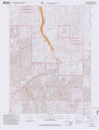
2001 Map of Callahan
USGS Topo · Published 2004About this map
Scott Valley forms the central corridor of this Siskiyou County landscape, where the confluence of the East Fork Scott River and the South Fork Scott River at Callahan anchors the local geography. This high-altitude terrain is defined by its deep mining history and industrial utility, evidenced by the McKeen Mine, Blue Mine, and Stop Mine scattered across the surrounding ridges. The survey illustrates a working landscape within the Klamath National Forest, where resource extraction and water management are prominent through features like an Aqueduct and various gravel pits.
Find a feature on this map
39 named features on this map. Tap any name to fly to it.
Don’t see what you’re looking for? This feature index may not catch every label — zoom into the map to look around manually.
Map Details
Editions of this 2001 Callahan Map
2 editions found
Other maps of this area

1886 · Shasta
USGS Topo · 1:250,000

1894 · Shasta
USGS Topo · 1:250,000

1923 · Sawyers Bar
USGS Topo · 1:125,000

1931 · Etna
USGS Topo · 1:96,000

1934 · Etna
USGS Topo · 1:125,000

1948 · Weed
USGS Topo · 1:250,000

1950 · Weed
USGS Topo · 1:250,000
1955 · Bonanza King
USGS Topo · 1:62,500
1955 · China Mountain
USGS Topo · 1:62,500

1955 · Etna
USGS Topo · 1:62,500