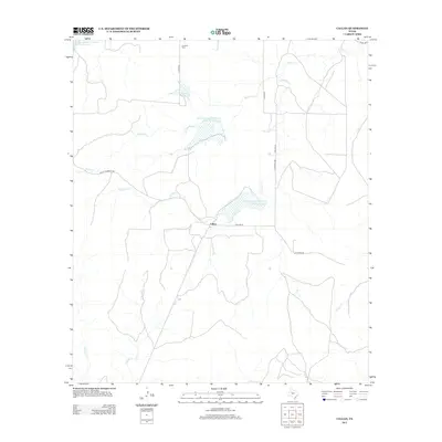
2013 Map of Callan
USGS Topo · Published 2013About this map
The small settlement of Callan serves as the central point for this Menard County landscape, situated where Callan Ln and Callan Number 1 Rd meet. The area is defined by a series of north-south drainage systems, including Reubes Cr, Fountain Cr, and Needle Cr, which feed into several water management projects. These include the Soil Conservation Service Site 19 Reservoir and Soil Conservation Service Site 18a Reservoir, reflecting the 20th-century emphasis on flood control and livestock watering in this ranching region. Genealogists and local historians can locate Loveless Cem in the northern portion of the map, while the placement of Lockett Lake and various county roads like Co Rd 3615 indicate the enduring rural infrastructure of the early 21st century.
Find a feature on this map
17 named features on this map. Tap any name to fly to it.
Don’t see what you’re looking for? This feature index may not catch every label — zoom into the map to look around manually.
Map Details
Editions of this 2013 Callan Map
This is the sole edition of this map. No revisions or reprints were ever made.
Other maps of this area

1892 · Eden
USGS Topo · 1:125,000

1896 · Eden
USGS Topo · 1:125,000

1954 · Brownwood
USGS Topo · 1:250,000

1954 · Llano
USGS Topo · 1:250,000

1955 · Llano
USGS Topo · 1:250,000

1956 · Llano
USGS Topo · 1:250,000

1960 · Melvin
USGS Topo · 1:24,000

1970 · Callan
USGS Topo · 1:24,000
1970 · Needle Creek
USGS Topo · 1:24,000
1970 · Eden
USGS Topo · 1:24,000