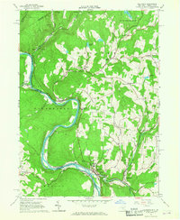
1965 Map of Callicoon
USGS Topo · Published 1967About this map
The Delaware River defines the winding border between New York and Pennsylvania on this mid-1960s survey, where the Erie Lackawanna railroad snakes along the northern bank. The settlement of Callicoon serves as a local hub, featuring institutional landmarks like St Josephs Seminary and the Athletic Field. Upstream, the landscape is marked by several small hamlets such as Hortonville, Hankins, and Mileses, connected by roads that traverse high points like Cherry Ridge and Long Ridge.
Find a feature on this map
50 named features on this map. Tap any name to fly to it.
Don’t see what you’re looking for? This feature index may not catch every label — zoom into the map to look around manually.
Map Details
Editions of this 1965 Callicoon Map
Other maps of this area

1920 · Long Eddy
USGS Topo · 1:62,500

1920 · Damascus
USGS Topo · 1:62,500

1921 · Long Eddy
USGS Topo · 1:48,000

1921 · Livingston Manor
USGS Topo · 1:62,500

1922 · White Lake
USGS Topo · 1:62,500

1923 · Damascus
USGS Topo · 1:62,500

1923 · Long Eddy
USGS Topo · 1:62,500

1923 · Livingston Manor
USGS Topo · 1:62,500

1942 · White Lake
USGS Topo · 1:62,500

1943 · Honesdale
USGS Topo · 1:125,000