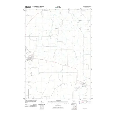
2010 Map of Calmar
USGS Topo · Published 2010About this map
Calmar and Ossian serve as the primary hubs in this corner of Winneshiek County during the early 21st century. The landscape is defined by a dense grid of rural roads and the drainage networks of the Trout Creek, North Fork Yellow River, and Brockamp Creek. Genealogists will find significant value in the numerous burial sites across the township, including the Springfield Cemetery, the family-named Bruvold Farm Cemetery, and the Saint Aloysius Cemetery near the center of Calmar. The settlement at Nordness and the landmark Twin Springs further ground the map in its local geography. This survey provides a clear view of the intersection between historic town sites and the surrounding agricultural landscape, with the Calmar Post Office and Ossian Post Office marking the centers of civic activity.
Find a feature on this map
49 named features on this map. Tap any name to fly to it.
Don’t see what you’re looking for? This feature index may not catch every label — zoom into the map to look around manually.
Map Details
Editions of this 2010 Calmar Map
This is the sole edition of this map. No revisions or reprints were ever made.
Other maps of this area

1906 · Decorah
USGS Topo · 1:125,000

1958 · La Crosse
USGS Topo · 1:250,000

1961 · La Crosse
USGS Topo · 1:250,000

1965 · La Crosse
USGS Topo · 1:250,000

1975 · Decorah 4 NW
USGS Topo · 1:24,000

1975 · Decorah 1 SW
USGS Topo · 1:24,000

1975 · Decorah 3 NW
USGS Topo · 1:24,000

1975 · Decorah 2 SW
USGS Topo · 1:24,000
1975 · Decorah 3 NE
USGS Topo · 1:24,000
1975 · Decorah 2 SE
USGS Topo · 1:24,000