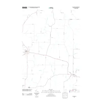
2013 Map of Calmar
USGS Topo · Published 2013About this map
The agricultural landscape of Winneshiek County is defined by the convergence of several small waterways and established transportation routes in this 2013 survey. Calmar and Ossian serve as the primary hubs, connected by a network of rural roads including the historic Lincoln Hwy Rd and Co Hwy W42. The area is characterized by its drainage into the Yellow River system, with the N Fork Yellow River and Nutting Cr carving paths through the rolling farmland. Smaller settlements like Nordness in the north and Twin Springs in the southwest anchor the rural community. The map provides a precise look at the modern layout of residential streets such as Henry St and Clay St in Calmar, alongside the winding courses of Trout Cr and Brockamp Cr.
Find a feature on this map
61 named features on this map. Tap any name to fly to it.
Don’t see what you’re looking for? This feature index may not catch every label — zoom into the map to look around manually.
Map Details
Editions of this 2013 Calmar Map
This is the sole edition of this map. No revisions or reprints were ever made.
Other maps of this area

1906 · Decorah
USGS Topo · 1:125,000

1958 · La Crosse
USGS Topo · 1:250,000

1961 · La Crosse
USGS Topo · 1:250,000

1965 · La Crosse
USGS Topo · 1:250,000

1975 · Decorah 4 NW
USGS Topo · 1:24,000

1975 · Decorah 1 SW
USGS Topo · 1:24,000

1975 · Decorah 3 NW
USGS Topo · 1:24,000

1975 · Decorah 2 SW
USGS Topo · 1:24,000
1975 · Decorah 3 NE
USGS Topo · 1:24,000
1975 · Decorah 2 SE
USGS Topo · 1:24,000