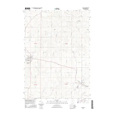
2015 Map of Calmar
USGS Topo · Published 2015About this map
Calmar and Ossian anchor this Winneshiek County landscape, connected by a network of rural roads such as Middle Ossian Rd and Lincoln Hwy Rd. The topography is defined by the winding paths of the Yellow River and its tributaries, including Trout Cr and Nutting Cr. This area is a significant hub for regional education, featuring the Northeast Iowa Community Coll Calmar Campus situated on the southern edge of town.
Find a feature on this map
66 named features on this map. Tap any name to fly to it.
Don’t see what you’re looking for? This feature index may not catch every label — zoom into the map to look around manually.
Map Details
Editions of this 2015 Calmar Map
This is the sole edition of this map. No revisions or reprints were ever made.
Other maps of this area

1906 · Decorah
USGS Topo · 1:125,000

1958 · La Crosse
USGS Topo · 1:250,000

1961 · La Crosse
USGS Topo · 1:250,000

1965 · La Crosse
USGS Topo · 1:250,000

1975 · Decorah 4 NW
USGS Topo · 1:24,000

1975 · Decorah 1 SW
USGS Topo · 1:24,000

1975 · Decorah 3 NW
USGS Topo · 1:24,000

1975 · Decorah 2 SW
USGS Topo · 1:24,000
1975 · Decorah 3 NE
USGS Topo · 1:24,000
1975 · Decorah 2 SE
USGS Topo · 1:24,000