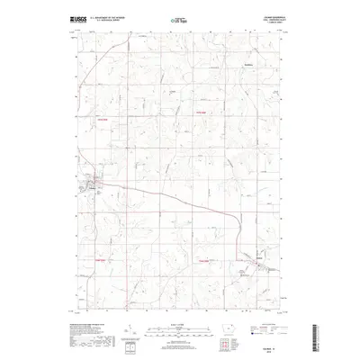
2018 Map of Calmar
USGS Topo · Published 2018About this map
The town of Calmar serves as a key settlement hub in this portion of Winneshiek County, situated at the intersection of several regional routes and the historic rail corridor. To the southeast lies Ossian, another primary population center characterized by its proximity to the headwaters of the Yellow River. The landscape between these towns is defined by productive agricultural land and a dense network of country roads such as Middle Ossian Rd and Middle Calmar Rd. Local history is preserved in several rural burial grounds, including the Springfield Cem and the Bruvold Farm Cem north of the river. Numerous small waterways, including Brockamp Cr and Nutting Cr, drain the terrain, illustrating the drainage patterns that have influenced farmstead placement for generations. The inclusion of the Saint Aloysius Cem in Calmar and the Saint Francis Desales Cem near Ossian highlights the religious and community foundations of these Iowa settlements.
Find a feature on this map
65 named features on this map. Tap any name to fly to it.
Don’t see what you’re looking for? This feature index may not catch every label — zoom into the map to look around manually.
Map Details
Editions of this 2018 Calmar Map
This is the sole edition of this map. No revisions or reprints were ever made.
Other maps of this area

1906 · Decorah
USGS Topo · 1:125,000

1958 · La Crosse
USGS Topo · 1:250,000

1961 · La Crosse
USGS Topo · 1:250,000

1965 · La Crosse
USGS Topo · 1:250,000

1975 · Decorah 4 NW
USGS Topo · 1:24,000

1975 · Decorah 1 SW
USGS Topo · 1:24,000

1975 · Decorah 3 NW
USGS Topo · 1:24,000

1975 · Decorah 2 SW
USGS Topo · 1:24,000
1975 · Decorah 3 NE
USGS Topo · 1:24,000
1975 · Decorah 2 SE
USGS Topo · 1:24,000