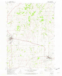
1981 Map of Calmar
USGS Topo · Published 1982About this map
Calmar and Ossian serve as the primary rail-connected hubs of this Winneshiek County landscape in the early 1980s. The Chicago Milwaukee St Paul and Pacific railroad cuts a diagonal path through the center of the survey, linking these two major settlements while remnants of an Old Railroad Grade suggest the evolution of the regional transport network. Institutional landmarks are prominent, including the Area 1 Vo-Tech Sch near the St Aloysius Cem and the Springfield Ch situated to the north.
Find a feature on this map
27 named features on this map. Tap any name to fly to it.
Don’t see what you’re looking for? This feature index may not catch every label — zoom into the map to look around manually.
Map Details
Editions of this 1981 Calmar Map
This is the sole edition of this map. No revisions or reprints were ever made.
Other maps of this area

1906 · Decorah
USGS Topo · 1:125,000

1958 · La Crosse
USGS Topo · 1:250,000

1961 · La Crosse
USGS Topo · 1:250,000

1965 · La Crosse
USGS Topo · 1:250,000

1975 · Decorah 4 NW
USGS Topo · 1:24,000

1975 · Decorah 1 SW
USGS Topo · 1:24,000

1975 · Decorah 3 NW
USGS Topo · 1:24,000

1975 · Decorah 2 SW
USGS Topo · 1:24,000
1975 · Decorah 3 NE
USGS Topo · 1:24,000
1975 · Decorah 2 SE
USGS Topo · 1:24,000