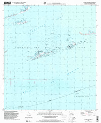
1998 Map of Calumet Island
USGS Topo · Published 2001About this map
Timbalier Bay and the surrounding barrier islands define this coastal landscape at the edge of the Gulf of Mexico. The map illustrates the industrial intensity of the late 20th century, where the natural geography of Casse-Tete Island and East Timbalier Island is heavily marked by energy infrastructure. Extensive networks of pipelines and numerous offshore platforms dominate the waters, particularly within the Timbalier Bay Oil and Gas Field and Block 21 Oil Field.
Find a feature on this map
26 named features on this map. Tap any name to fly to it.
Don’t see what you’re looking for? This feature index may not catch every label — zoom into the map to look around manually.
Map Details
Editions of this 1998 Calumet Island Map
This is the sole edition of this map. No revisions or reprints were ever made.
Other maps of this area

1892 · Cheniere Caminada
USGS Topo · 1:62,500

1894 · Timbalier
USGS Topo · 1:62,500

1935 · Timbalier Island
USGS Topo · 1:31,680

1935 · Pelican Pass
USGS Topo · 1:31,680

1935 · Calumet Island
USGS Topo · 1:31,680

1935 · Leeville
USGS Topo · 1:31,680

1945 · New Orleans
USGS Topo · 1:250,000

1945 · Leeville
USGS Topo · 1:31,680

1947 · Jacko Bay
USGS Topo · 1:31,680
1949 · Belle Pass
USGS Topo · 1:31,680