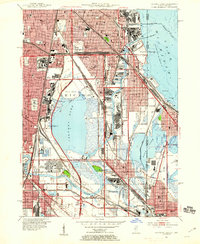
1953 Map of Calumet Lake
USGS Topo · Published 1955About this map
Calumet Lake and its industrial surroundings dominate this mid-century landscape on the Chicago South Side. The map reveals a dense network of heavy industry and shipping infrastructure, including Turning Basin No. 5 and the expansive Dumping Grounds north of the lake. Long-established neighborhoods like Pullman and Kensington appear alongside more recent developments like the Altgeld Gardens housing project. The area's reliance on rail transport is evident in the numerous lines of the New York Central System and the Chicago Rock Island and Pacific RR that crisscross the wetlands. To the east, the state line divides the industrial heart of South Chicago from the residential and recreation areas around Wolf Lake and Robertsdale in Indiana. Notable community landmarks such as Chicago Vocational Sch and Eckersall Stadium reflect the civic growth of these South Side communities during this period of high industrial productivity.
Find a feature on this map
89 named features on this map. Tap any name to fly to it.
Don’t see what you’re looking for? This feature index may not catch every label — zoom into the map to look around manually.
Map Details
Editions of this 1953 Calumet Lake Map
This is the sole edition of this map. No revisions or reprints were ever made.
Other maps of this area

1889 · Chicago
USGS Topo · 1:62,500

1891 · Chicago
USGS Topo · 1:62,500

1892 · Calumet
USGS Topo · 1:62,500

1893 · Calumet
USGS Topo · 1:62,500

1900 · Chicago
USGS Topo · 1:62,500

1900 · Toleston
USGS Topo · 1:62,500

1900 · Calumet
USGS Topo · 1:62,500

1901 · Calumet
USGS Topo · 1:62,500

1901 · Chicago
USGS Topo · 1:62,500

1929 · Calumet Lake
USGS Topo · 1:24,000