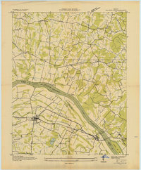
1936 Map of Calvert City
USGS Topo · Published 1936About this map
Calvert City and Gilbertsville anchor this 1936 survey of the Tennessee River corridor, captured just as the Tennessee Valley Authority began its monumental transformation of the region's landscape. The river, labeled here as Ohio River Pool 52, is the primary artery for local commerce, supported by vital river crossings like Haddox Ferry and Gilbertsville Ferry. The Illinois Central railroad cuts through the southern half of the quadrangle, serving the industrial siding at Gravel Switch and the agricultural hub at Calvert City.
Find a feature on this map
57 named features on this map. Tap any name to fly to it.
Don’t see what you’re looking for? This feature index may not catch every label — zoom into the map to look around manually.
Map Details
Editions of this 1936 Calvert City Map
This is the sole edition of this map. No revisions or reprints were ever made.
Other maps of this area

1928 · Eddyville
USGS Topo · 1:48,000

1929 · Smithland
USGS Topo · 1:62,500

1931 · Eddyville
USGS Topo · 1:62,500

1936 · Elva
USGS Topo · 1:24,000

1936 · Eddyville
USGS Topo · 1:48,000

1936 · Grand Rivers
USGS Topo · 1:24,000

1936 · Smithland
USGS Topo · 1:48,000

1936 · Benton
USGS Topo · 1:48,000

1936 · Birmingham
USGS Topo · 1:24,000

1936 · Golden Pond
USGS Topo · 1:48,000