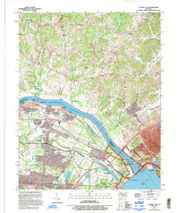
1993 Map of Calvert City
USGS Topo · Published 1996About this map
The Tennessee River dominates this landscape, serving as the border between Livingston and Marshall counties as it flows toward its confluence with the Ohio River Pool 52. This 1993 revision documents the industrial and recreational evolution of the region, anchored by the massive Kentucky Dam and the expansive Kentucky Lake. The area around Calvert City is marked by significant industrial infrastructure, including a Filtration Plant, Tailings Pond, and multiple pumping stations, illustrating the mid-century transition toward heavy industry and water management.
Find a feature on this map
49 named features on this map. Tap any name to fly to it.
Don’t see what you’re looking for? This feature index may not catch every label — zoom into the map to look around manually.
Map Details
Editions of this 1993 Calvert City Map
This is the sole edition of this map. No revisions or reprints were ever made.
Other maps of this area

1928 · Eddyville
USGS Topo · 1:48,000

1929 · Smithland
USGS Topo · 1:62,500

1931 · Eddyville
USGS Topo · 1:62,500

1936 · Elva
USGS Topo · 1:24,000

1936 · Eddyville
USGS Topo · 1:48,000

1936 · Grand Rivers
USGS Topo · 1:24,000

1936 · Smithland
USGS Topo · 1:48,000

1936 · Benton
USGS Topo · 1:48,000

1936 · Birmingham
USGS Topo · 1:24,000

1936 · Golden Pond
USGS Topo · 1:48,000