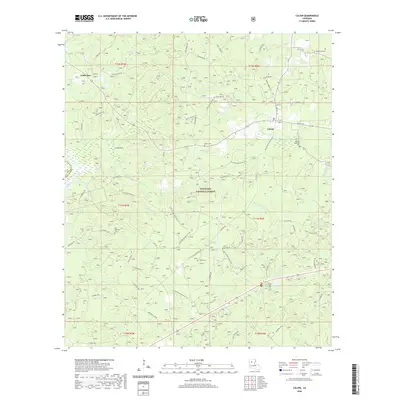
2020 Map of Calvin
USGS Topo · Published 2020About this map
Kisatchie National Forest dominates the southern landscape of this Winn Parish quadrangle, where a network of trails and forestry roads cuts through the woodland. The settlement of Calvin serves as a local hub near Kyiates Cr, while the community of Coldwater sits further west near Spring Br. The terrain is defined by a dense drainage system of creeks and branches, including Mill Cr, White Oak Cr, and Gravel Cr, which have shaped the local topography and settlement patterns. For those researching family history in this part of Louisiana, several burial grounds are documented, including Old Harmony Cem, Blake Cem, Franks Cem, and Bethlehem Cem. The map also traces the long-standing Gum Springs Horse Trail as it winds through the federally protected forest lands, illustrating the area's transition from early timber works to modern recreational and conservation use.
Find a feature on this map
66 named features on this map. Tap any name to fly to it.
Don’t see what you’re looking for? This feature index may not catch every label — zoom into the map to look around manually.
Map Details
Editions of this 2020 Calvin Map
This is the sole edition of this map. No revisions or reprints were ever made.
Other maps of this area

1947 · Goldonna
USGS Topo · 1:62,500

1949 · Calvin SE
USGS Topo · 1:31,680

1949 · Calvin NE
USGS Topo · 1:31,680

1949 · Calvin NW
USGS Topo · 1:31,680

1949 · Calvin SW
USGS Topo · 1:31,680

1949 · Jonesboro
USGS Topo · 1:62,500

1950 · Jonesboro
USGS Topo · 1:62,500

1950 · Winnfield
USGS Topo · 1:62,500

1951 · Winnfield
USGS Topo · 1:62,500

1953 · Alexandria
USGS Topo · 1:250,000